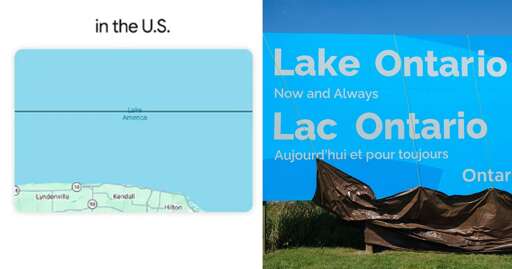
People using the application will see the new name in U.S., but will see Lake Ontario in Canada. Outside of North America, users will see both names for the lake.
OSMAnd is really good, but it’s pretty slow with a clunky interface and an unpleasant theme. CoMaps has a very streamlined UI, a pleasant theme and very good performance.
I still keep both since OSM is more feature rich especially for elevation (important when cycling), but for day to day use CoMaps is the one I use.
Both are fully Open Source and use OSM data so I’m not worried much about them going to shit, though I’m under the impression CoMaps is non-profit more community built, while OSMAnd is a for small for-profit with still a community behind.


OSMAnd is really good, but it’s pretty slow with a clunky interface and an unpleasant theme. CoMaps has a very streamlined UI, a pleasant theme and very good performance.
I still keep both since OSM is more feature rich especially for elevation (important when cycling), but for day to day use CoMaps is the one I use.
Both are fully Open Source and use OSM data so I’m not worried much about them going to shit, though I’m under the impression CoMaps is non-profit more community built, while OSMAnd is a for small for-profit with still a community behind.